The problem
Many members of the planning and land development communities tell us that they are time poor, constantly busy and need reliable ways of land searching whilst assessing risk. Identifying, evaluating, buying and developing off-market land for residential use is often a long drawn out process carried out in a very competitive environment. Availability of effective tools to speed up processes and increase productivity can be the difference between commercial success or failure of a venture. LandHawk is such a tool. It enables rapid, reliable identification of land parcels that match development criteria. Other core benefits of the solution are increased speed and time saving throughout the process of acquisition, planning and development, informing decisions that enable maximisation of profit at all stages.
The current landscape
Competitive solutions do exist but take-up has been limited by relatively high costs, lack of flexibility and limited feature sets. Users express frustration related to these issues. LandHawk creates a new paradigm for the industry providing new levels of information access, automation, processing capability and customisability at affordable and cost effective price points, leading to significant ROI benefits for client organisations.
LandHawk is aligned to the UK’s National Planning Policy Framework (NPPF) and we are working hard to bring that to a local policy level too. Planning data is weighted and used by the system to return more checks with greater accuracy than any comparable systems. This removes the need for the user to utilise two or even three different subscription based services to obtain and validate required results, reducing costs and speeding up the process by up to 70%. A single, fast, effective and joined up process is created reducing complexity and administrative workload.
LandHawk is also the first platform able to calculate and display in 3D the layout and number of houses (of particular sizes and specifications) that could be built on a particular parcel of land. LandHawk can perform this process in seconds providing developers and planners with a first look at how the site under evaluation would look post development without the need to involve architects or undertake any costly work. This is the first web-based virtual house building tool of its kind. The user simply selects the boundary of land that is to be filled with houses and/or other types of buildings and LandHawk will build them on a 3D map of the location to the correct height, distance apart and inclusive of roads, greenspace, play parks, schools and anything else that would need to be built depending on the size of the area. This at a glance tool provides a base for cost, time and resources allowing viability to be worked out fast. We can’t wait to release this!
How does it all work?
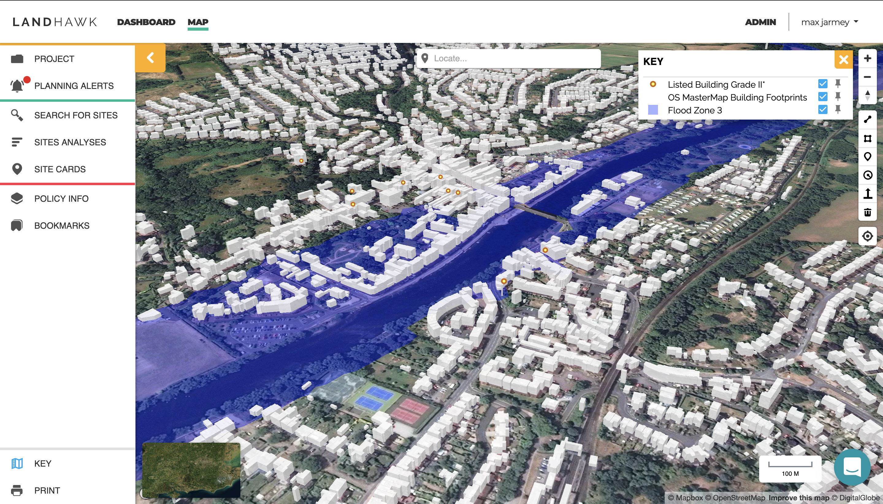
Designed using bespoke algorithms created by the development team at LandHawk, the system accesses more than 100 relevant data sets and weights data related to an investigation (site search) to give a score for each site. By combining scores from relevant data sets it returns an overall score for each site with a traffic light report showing red, amber, green flags relating to degree of suitability of the site when measured against the selection criteria. All selected sites can then be quickly compared for suitability by the user. This report is produced once the search criteria have been selected, usually within seconds. Users can select just one parcel of land or search an entire area for suitable locations to develop.
There is a very clever cross-weighting system too, so the correct result is returned even if areas with different scores overlap each other.
The LandHawk data sets are aligned to the NPPF, but they can be fully customised so if a user has a different set of criteria or data, values can be returned to create a report that reflects the bespoke criteria rather than planning framework rules. The platform also contains workflows and live updates so the user is notified of any changes to the land in real time, particularly important for planning applications.
The result
UK land developers now have everything they need to execute the development process in one platform that provides results relating to most queries in seconds. The time and cost savings that LandHawk provides can be realised in many land development related organisations from Estate Agents with Land & New Home departments to Architects, Engineers and Local Authority Planning teams. It can even be used by conveyancing solicitors to look into a client purchase and understand the level of risk involved.
The platform is a low cost alternative to the competition also, easily paying for itself in productivity gains alone. LandHawk will revolutionise the land buying process for developers.