What is ‘Net Developable Area’?
This is the available area/zone within a parcel of land in which there is potential to build housing or some other type of permanent structure. Another way of looking at this is that it is the area with the most financial opportunity!
How often do you notice patches of seemingly viable land by the side of the road and wonder why no one bought it to stick a load of houses on. Ridiculous, right? Well, not completely, there are a number of risks and constraints which are associated with land that are not obvious at first sight. One big example of this is where a parcel of land is at risk of flooding or is contaminated to an extent that it would be too expensive to rectify and get through a planning application process.
It’s a risk for a land developer that can get expensive, so there is a need to ensure whatever land they are potentially purchasing carries a minimum amount of risk.
Almost every data we record nowadays has a location, or to be technical, a geospatial element. By using digital maps and geospatially enabled tools, we can do math and statistics on where things interact or are near to one another. Geospatial is the 4th industrial revolution and we are investing heavily because we understand the importance of knowing where things happen as much as cost or shape.
Within the UK, the Ministry of Housing, Communities & Local Government (MHCLG) are reviewing the data which is used by housing tools so that the process becomes more efficient. We’ve spent hours reviewing and quantifying this geospatial data to ensure the accuracy, quality, resolution and detail work together to provide an intelligent and useful result. Furthermore, we’ve built our analysis in such a way that we can add data from users to personalise the results, how cool is that?!
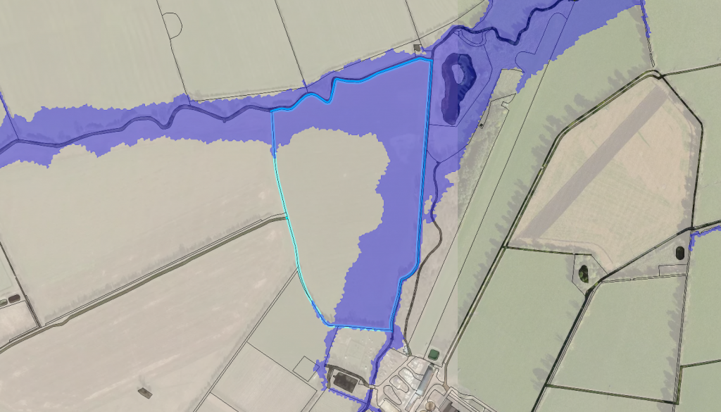
Utilising geospatial data expertise and online Geospatial Information Systems (GIS) like LandHawk, land developers now have the ability to visualise which area within a piece of land has the most opportunity of development success. The image shown above is, to the trained eye, relatively obvious. It is only made possible by visualising land boundaries alongside the flood zone 3 data within a GIS. You can simply view the area within the parcel (highlighted in blue) that does not have the Flood Zone 3 running through it.
So what percentage of this site has opportunity and what are the measurements of the ‘Net Developable Area’? To be able to begin to understand the viability of the land for development, these are questions that need answering.
At LandHawk we are able to provide all this statistical information for not only one parcel of land, but hundreds, if not thousands. Other geospatial data can be added to the criteria, because as we know, not all opportunities are the same. One land developer could have differing criteria from another. This is all possible within the platform.
We hope this goes some way to explaining ‘Net Developable Area’ and gives you some ideas on how you can enhance your land development opportunities as land developers or strategic planners. We are working closely with a number of private and public authorities to undertake this type of analysis across the UK, helping them to understand development and investment opportunities for their portfolios of land and to find reliable, speculative opportunities.
To learn more, book a demo with us using the link below.