ABEI Energy is an Independent Power Producer (IPP) engaged in the full management of renewable energy projects from development and construction through to operation and maintenance. They are actively growing their operations in the UK, dealing across multiple renewable capabilities including photovoltaic, biomass, wind and hydroelectric.
Currently operating in Europe and America, ABEI Energy is committed to helping the UK achieve its zero emissions targets and are constantly on the lookout for new sites to develop. They engaged LandHawk to help them identify potential development sites faster and risk assess them against their very specific custom criteria. Our in-house team of geospatial experts helped to design a bespoke solution to meet their needs now and into the future.
Challenge
The growth plans that ABEI Energy have hinge on the identification and development of new renewable infrastructure, carried out by their project development team. The process they were using was time consuming and outdated, involving the use of multiple siloed resources and geospatial expertise to search for and assess opportunities.
Their specific criteria of search requirements meant the results were inaccurate and slow to process. They needed a system that allowed for personal data ingestion plus the personalisation of site analysis results, which they were struggling to find until they discovered LandHawk’s capabilities.
Solution
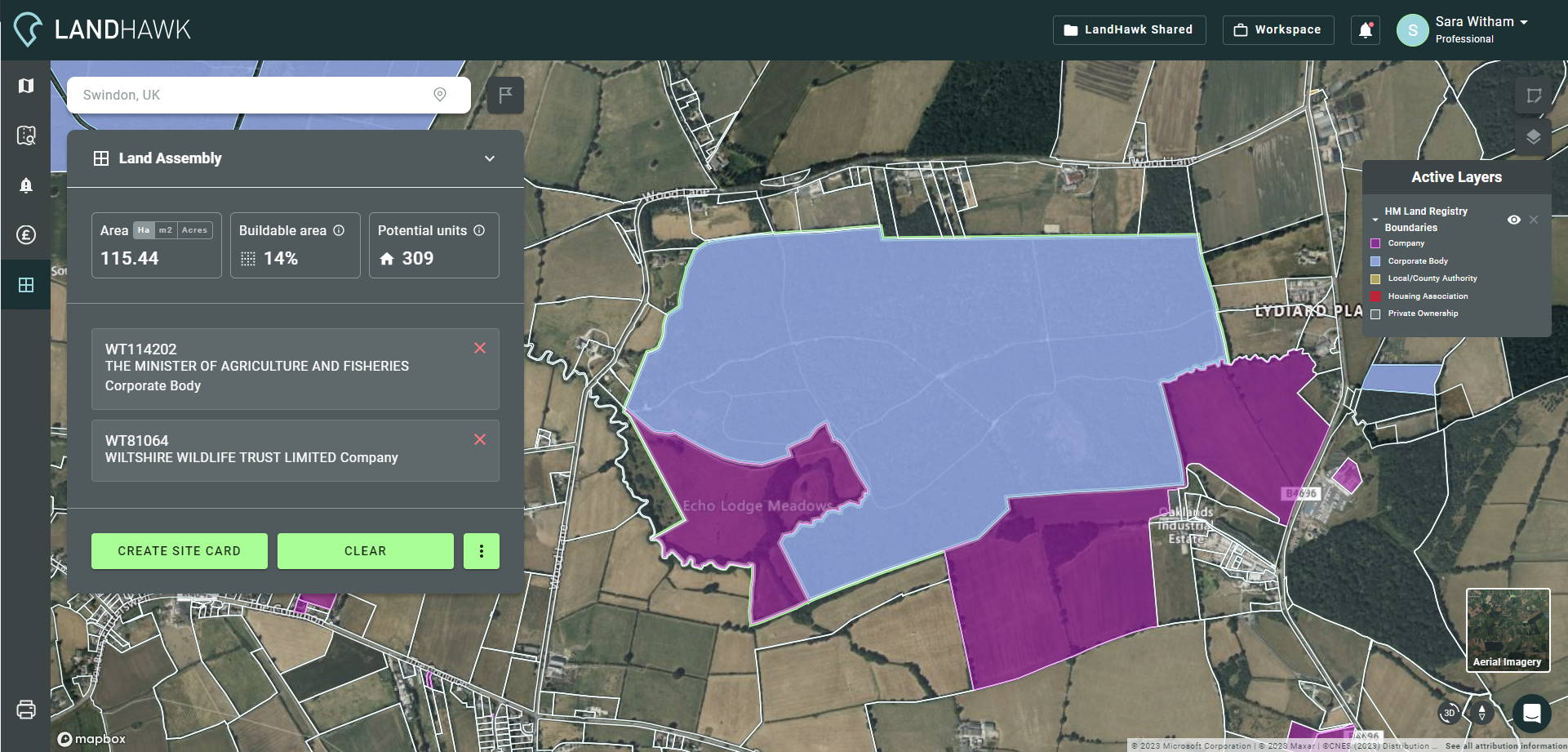
The team at LandHawk quickly identified that their geospatially enabled site identification and viability assessment platform would be able to deliver the customisation capability that ABEI Energy required to find and assess potential development sites quickly.
The bespoke nature of the project required a full enterprise service, including a customised solution to meet ABEI Energy’s exact requirements for site searching. ABEI Energy needed to know specific detail such as impact in relation to agricultural land classification and proximity to substation and gridlines.
LandHawks team of geospatial experts set up custom data ingestion, Distribution Network Operator (DNO) gridline and substation location data. This included a custom site analysis weighting profile to include DNO data with risk scoring to only highlight sites that ABEI Energy deem developable.
A custom nationwide HMLR dataset was also set up, joining all touching land parcels with the same ownership, allowing ABEI Energy to instantly understand marriage opportunities across land ownerships. There are also future plans for fully automated DNO data updates.
“Working with LandHawk has been a very smooth process and they’ve really understood our requirements. The custom nature of what we needed to get out of the platform wasn’t readily available elsewhere and the team took the time to understand what we needed. We’re now able to find the right development sites without the need to rely on multiple resources to deliver, allowing us to deliver important projects faster.”
Rob Morris, Project Developer, ABEI Energy
Benefits
Now the team at ABEI Energy have a one stop shop solution in the LandHawk platform. It enables them to quickly view planning applications, environmental constraints, run custom searches, analyse results and manage land acquisition opportunities, much quicker and more reliably than ever before.
Access to the DNO data is now within the same platform as environmental designations and land parcels, this allows ABEI Energy to view data in context with each other, negating reliance on GIS and geospatial expertise.
By having greater collaboration between departments and everything on one platform – project developers can allow the data teams to rapidly identify viable opportunities through the automated search for sites. Manual collation of data is now no longer a restraint on project delivery times.
LandHawk have helped ABEI Energy remove the time and cost drain associated with their previous methods for impact assessment and automated their search process – hugely reducing current manual effort expended by Geospatial Technicians – bringing them in line with achieving their growth plans and environmental targets.